Scenic Running Routes in Billings
6 Scenic Running Routes in Billings
Billings has some incredibly beautiful running routes!
Black Otter Trail to Alkali Creek Rd Loop
Where: Billings' Heights
Distance: about 8 miles
Terrain: dirt/paved
Depending on your desired distance, you can start at either trailhead of Swords Park (near the airport or the east trailhead) and follow Black Otter Trail through the tunnel to Alkali Creek Road. There you can follow the paved trail along Alkali Creek Road, turn onto Senators Boulevard, and then turn onto Judicial Avenue and follow it until you hit a “primitive” dirt trail where you can get some training on the dirt. For a shorter run, simply run the Swords Park section of the trail or park and begin at the east trailhead of Swords Park.
Route map for Black Otter Trail To Alkali Creek by Jessica Baldwin on plotaroute.com
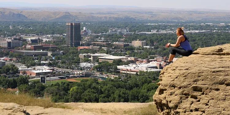
Four Dances Natural Recreation Area
Where: East of Billings (Sacrifice Cliff is included)
Distance: just over 3 miles
Terrain: dirt/rock/unpaved
See the city from the other side of the rims at the Four Dances Natural Recreation area. This is a BLM section of land and features a natural stretch of trails, so watch for snakes! You can run along the trails, which will take you along Sacrifice Cliff. Be sure to stop and take in the view of downtown Billings and the Yellowstone River while
Route map for Four Dances Recreation Area by Jessica Baldwin on plotaroute.com
Airport to Zimmerman Park and Back
Where: On top of the Rims
Distance: about 8 miles
Terrain: dirt
On top of the Rims... Does a running route get a better view? I don’t think so! There are some great dirt paths all across the Rims so you can get some extra running inspiration feeling like you are on top of the world (or on top of Billings at least). To increase your distance a bit and enjoy a little wilderness, take a run through Zimmerman Park on the dirt paths. Zimmerman Park trails are not paved and it’s a natural park, so please be careful. Watch your footing and watch for snakes. For a shorter run, park anywhere along Airport Road that’s closer to Zimmerman Park and start from there.
Route map for Airport To Zimmerman, Billings by Jessica Baldwin on plotaroute.com
Pioneer Park Loop
Where: Central Billings
Distance: 3 Miles
Terrain: paved
At about three miles, this is a great route for beginners and those training for a 5K. This route takes you through and along the nicely shady Pioneer Park and up along the tree streets near Highlands Golf Club.
Route map for Pioneer Park Loop by Jessica Baldwin on plotaroute.com
Jim Dutcher Trail beginning at Two Moon Park
Where: Begins in the Heights
Distance: About 9 miles when you start at Two Moon Park
Terrain: paved
The Jim Dutcher Trail takes runners through four parks and along the Yellowstone River. Begin up at Two Moon Park and follow the paved trail behind MetraPark and through Earl Guss Park. Follow the path along the Yellowstone River at Coulson Park and to the end of the trail at Mystic Park where you can turn around and head back.
Route map for Pioneer Park Loop by Jessica Baldwin on plotaroute.com
College Loop
Where: MSU Billings Campus
Distance: 5 Miles
Terrain: paved
Take a tour of Billings’ college campuses on this 5 mile loop. Begin at MSUB’s Tennis Bubble and run through campus to Virginia Lane. Go north to Rimrock Rd and follow it to 17th street where you can enter and run through the Rocky Mountain College Campus, through Veteran’s Park and back to MSUB on Parkhill Drive and Virginia Lane.
Route map for Pioneer Park Loop by Jessica Baldwin on plotaroute.com
Happy Running!